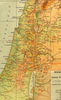
Full-color early twentieth-century Bible atlas styling with hypsometric tints, brown manual hachures, red-orange ancient labels and routes, dark serif regional names, and a cropped legend block at lower right.
OKLCH hue and lightness circle for History of the Hebrew Commonwealth
History of the Hebrew Commonwealth · Albert Edward Bailey; Charles Foster Kent
Map credit: L. L. Poates Engineering Co., N. Y.
Scribner: 1920
distinct hypsometric elevationmanual hachuresfull-color
Full-color early twentieth-century Bible atlas styling with hypsometric tints, brown manual hachures, red-orange ancient labels and routes, dark serif regional names, and a cropped legend block at lower right.
Label typography and visual context
Feature typeVisual contextLabel style
oceanSERIF
inland waterSERIF
Serif
riverSERIF
Serif
mountain Serif
Serif
natural regionSerif
political regionSERIF
SERIF
city Serif
Serif
Map symbols and color samples
Symbol roleVisual sample
text
water
river
wadi
road
hypsometric tint
graticule
boundary
other